Race Overview
Half Marathon
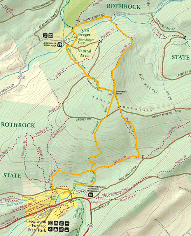
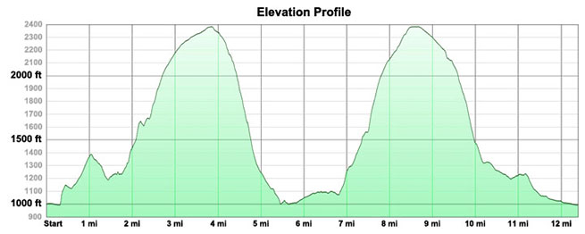
The approximate 13 mile figure 8 trail course will start at Greenwood Furnace State Park, traverse Rothrock State Forest to Alan Seeger Natural Area and back to the park. The route will be marked with orange flagging and volunteers will be stationed at all road crossings. The course features two brutal ascents and descents with some recovery in between. The trails include a stream crossing, 3 footbridge crossings, rock gardens, mud, and some nasty scrambling.
Behind Pavilion #1 runners will warm-up/walk/jog back to the rock furnace, where the race begins. Runners will run back the loop past the pavilion, up Chestnut spring trail briefly, cross the service road on to Spencer a wide, rolling abandoned service road. Off of Spencer Trail, runners will be directed left for their first brutal climb up Greenwood Spur (1200 feet). The spur starts steep but as you approach the Greenwood Tower it begins to level off (center of the figure 8).
At the tower runners will find a hydration/first station and be directed to their left to begin their descent down the Greenwood Spur to Alan Seeger Natural Area (~2 miles). The descent is gradual at first and then degrades from there into a steep scramble on loose rock gardens and intense switch backs.
When runners arrive at Alan Seeger Natural Area there is a stream crossing (Stone Creek), a hydration/snack station and some much needed recovery. The trail winds on level ground through the towering trees of Alan Seeger Natural Area crossing several foot bridges over Stone Creek. The Alan Seeger loops finishes on Alan Seeger Road where runners will be directed to Ross Trail just up the road on the right (3/4 of a mile).
Ross Trail is a daunting ascent (1300 feet) back to the tower (~2.5 miles). Its steepest part (no switchback) is in the middle coming just after running through a beautiful, yet muddy meadow of ferns and grasses and another footbridge crossing of Stone Creek. It begins to level off as runners approach the tower where any final hydration or aid may be found.
Runners will be directed left down a short section of grassy service road (~.5 miles) to access Ruff Gap Trail for their final descent. Ruff Gap is a scraggly consistently steep trail (~1 mile). At the bottom racers will be directed right on the level, grassy Spencer Trail (~1 mile). Volunteers will direct runners left on to Greenwood Spur for the final leg back to the pavilion (~1 mile).
Aid stations are marked on the map linked below.
10K
The approximate 10 Kilometer route will start at Greenwood Furnace State Park (at the furnace), traverse Rothrock State Forest to the fire tower by way of the Greenwood spur. The route will be marked with flagging and volunteers will be stationed at all road crossings. The course features a brutal ascent to the fire tower and a steep descent down Ruffed Gap trail.
Behind Pavilion #1 runners will warm-up/walk/jog back to the rock furnace, where the race begins. Runners will run back the loop past the pavilion, up Chestnut spring trail briefly, cross the service road on to Spencer a wide, rolling abandoned service road. Off of Spencer Trail, runners will be directed left for their first brutal climb up Greenwood Spur (1200 feet). The spur starts steep but as you approach the Greenwood Tower it begins to level off (center of the figure 8).
At the tower runners will find a hydration/first station and turn right to begin their descent back down to the Park. Runners will be directed down a short section of grassy service road (~.5 miles) to access Ruff Gap Trail for their final descent. Ruff Gap is a scraggly, consistently steep trail (~1 mile). At the bottom racers will be directed right on the level, grassy Spencer Trail (~1 mile). Volunteers will direct runners left on to Greenwood Spur for the final leg back to the pavilion (~1 mile).
Aid stations are marked on the map linked below.
Directions & Race Day Info
Greenwood Furnace State Park is located on Greenwood Rd (Rt. 305).
The phone number is (814) 667-1800.
Here's the park website if you want more information about the park itself.
From the west and north the park is best if accessed by 45 east and then 26 south (turn left on SR 305 at McAlevys Fort).
-----------------------------
From the east and south Rt 305 in Belleville can be accessed by route 655 (from the east route 322 Reedsville exit, from the south route 22).
Runners will be directed to park in the Stable Row loop at Greenwood Furnace State Park. Overflow and volunteers will be directed to the main parking area of the park in front of the office. Race registration (6:30-7:45 AM) will occur at Pavilion #1 (Continue on gravel road at the end of the Stable Row loop. Runners will be directed to walk/warm-up by walking the loop back toward the rock furnace- the starting line for a prompt 8:00 AM start. Park restrooms are located in the Stable Row loop. Additional temporary facilities will be located at the registration pavilion.


